
|
National anthem & map
|
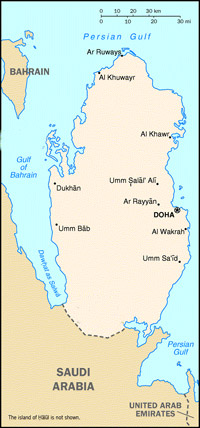
Location:
Qatar is a peninsula situated halfway along
the West Coast of the Arabian Gulf. It has a
number of islands, the most important of
which are Halool, Shira'aw, Al-Ashat and
others. Its topography consists of a rocky
flat surface with some limestone outcrops in
Dukhan area in the west and Fuwairit area in
the north. The surface is full with
characteristic depressions called Rawdat,
particularly in the north and central
plants.
Land Area:
The total land area of Qatar is
approximately 11,521 square kilometers.

Click Here To Download Doha
Map
To
Download this file you must have Adobe
acrobat |
 |
National flag: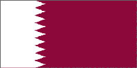
The national flag is maroon colour with a
broad vertical white stripe at the pole, the
two colours being separated with a
nine-point serrated line.
Meaning of the flag:
A- The white colour reflects the
internationally recognized symbol of peace.
B- The maroon colour symbolizes the
bloodshed during the several wars Qatar had
undergone, particularly in the second half
of the 19th century.
C- The nine-point serrated line indicates
that Qatar is the 9th member of the
"reconciled Emirates" of the Arabian Gulf in
the wake of concluding the Qatari-British
treaty in 1916. This information on design
and colour of Qatar flag was mentioned in
the Archives of the British Ministry of
Foreign Affairs in 1931.
|
|
|
 |
|